Previously: Traffic Helpdesk (First Part)
In the heat of mid-summer, roadworks done on some of the city's major arteries resulted in another round of gridlock. It wasn't Edsa this time, but the passages going to and from the heartland of Manila. One is along the Santa Mesa corridor between V. Mapa and Kalentong. A portion of the road lay exposed forcing vehicles to squeeze themselves against incoming traffic.
Situations like this are everywhere, I presume. School days are around the corner and contractors are working day and night to get the job done. But moving forward, it would not resolve the snarl at all. When rains come tumbling and the metropolis gets flooded, hardly there would be any movement across the city.
Thus, the choices available would be to wait - until the waters have subsided, or to wade across bacteria-infested deluge.
But there is hope.
Last year, an early morning thunderstorm had turned Ramon Magsaysay into a man-made lake. Only trucks can pass across - some even stalled at the middle of the boulevard. Timing and knowledge of the city's terrain allowed me to reach my office without having to sink my boots at all. It has become an advantage too that the LRT remained operational when roads became impassable.
Here's how it worked:
 |
| G. Reyes going to Pinaglabanan |
Location: J. Ruiz Station
This LRT station never gets flooded. Taxis abound since they cannot cross the bridge spanning the San Juan River near the UERM Hospital. The cab drivers would gladly accept commuters going to Shaw, as long as they explicitly say they won't reach Edsa.
Shortcut For:
Commuters coming in from Recto and U-Belt going to Ortigas Center and Pioneer Business District, and who has money to pay a taxi, and won't fight for space inside the MRT coaches in Cubao.
The Passage.
Instruct the driver to turn right at G. Reyes and then turn right again at N. Domingo. From N. Domingo, the cab has to turn left at Pinaglabanan and then turn right at P. Guevarra.
 |
| Pinaglabanan - P. Guevarra |
The passage across P. Guevarra takes you into the Chinese heartland of San Juan. Expect moderate traffic.
At the street after the Ministop Convenience Store, you have the option to tell the driver to turn left at Recto and then left again at P Burgos, which is the next street. Reaching the corner of McDonald's, you have to turn right at Wilson and the road ahead leads to Greenhills. Expect heavy traffic from thereon, especially upon nearing Edsa. Also, a caution: Burgos and parts of Wilson went underwater during the time of Ondoy.
Proceed with care.
 |
| Shaw Route (Pink), Greenhills/Ortigas Route (Cyan) |
The final leg of the shortcut takes you to the edges of Wack-Wack, where the back road meets the monstrous snarl of Shaw. At this point, expect the smooth cruise to turn into a stagger, since merging traffic from incoming vehicles (you) push their way into the already congested boulevard.
From P. Guevarra, turn hard left at Ortega. The other left street in this forked intersection leads you to Acacia Lane. (and Nueve de Febrero, a shortcut to Makati Avenue) At Ortega, there is another tricky intersection. Turn right at Pilar. The road ahead leads to Shaw, near the Puregold Supermarket.
But the car build-up will spoil everything you have done to make this short cut effective. The crawl itself recovers the time you have saved from waiting in line at the Cubao MRT station, or on a bus as it inches across Edsa.
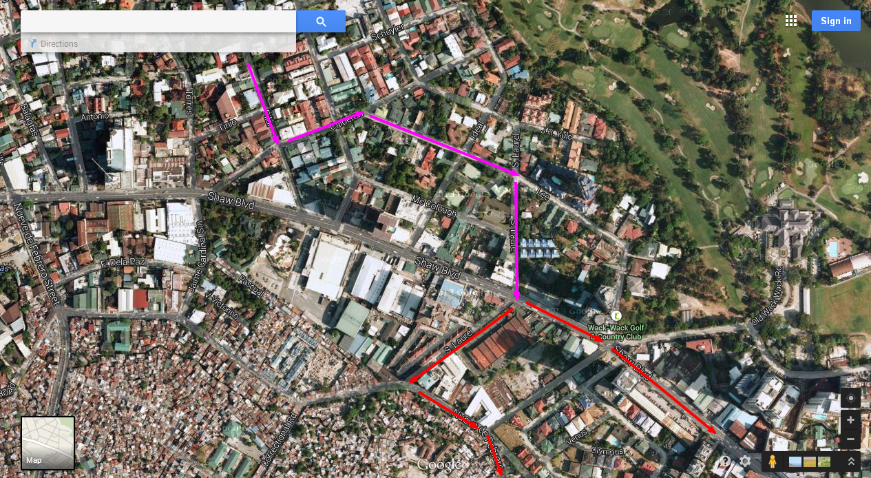 |
| All roads (Red Arrows) lead to Edsa |
Therefore, before Pilar drains into the mess which is Shaw Boulevard, turn left at Calderon, which is the last street before the boulevard. An intersection past and then turn right at Lee. On the second intersection, turn right again at S. Laurel street. At the end of this road is Shaw Boulevard and depending on your agreement with the cab driver, this is where you disembark to continue your journey - on foot, or by riding a jeep - to Edsa.
No comments:
Post a Comment